The Laser That's Changing the World by Todd Neff
Author:Todd Neff
Language: eng
Format: epub, azw3
ISBN: 9781633884670
Publisher: Prometheus Books
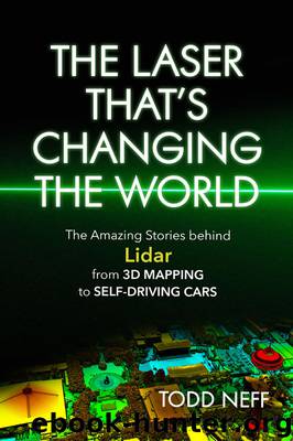
Downtown Seattle in November 2017, as captured by a Harris Geiger-mode lidar from an elevation of twelve thousand feet flying at 270 miles per hour. The color version shows things higher up, such as the Space Needle at right, in red hues, transitioning to greens and blues with decreasing elevation. (Photo courtesy of Harris Corporation.)
I wander into a panel with this title. It features high-end people from Harris, Leica Geosystems, Riegl, and Teledyne Optech, among others. They seem to agree they all have a role to play. The single-photon and Geiger-mode systems covering massive areas will be great for big customers interested in big scans, such as the government of North Carolina or perhaps a utility looking for a purview of all its infrastructure. But linear-mode lidar has its advantages too, in terms of faster turnaround time and an ability to fly under low clouds and dispatch on short notice, to far-off places, and in tight weather windows because there are many more of these systems available to take the call. There seems to be some consensus that these new machines from Harris and Leica Geosystems are best suited to regional- or even continental-scale collections, whereas linear-mode excels in mapping the corridor and city scale. But nobody really knows where all this is going.
The end customers don't seem to care how their mapping data show up as long as the information is good and as inexpensive as possible. Alvan Karlin, a geographic information systems expert at the Southwest Florida Water Management District encompassing the Tampa-St. Petersburg area, tells the room, “Whatever the most cost-effective technology that gets us the product we need is the route we'll go.”
A water manager in southwestern Florida uses lidar differently than one in the Rio Grande Basin. Karlin's sixteen-county, ten-thousand-square-mile district is concerned with water supply, flood protection, water quality, and the state of natural systems, he says. Lidar's been important in making sense of what Karlin describes as “Florida's deranged terrain,” one bereft of deeply cut basins, with topography riddled with soluble limestone sinkholes between which lazy rivers form. Flooding is the overriding focus, it seems: Karlin shows aerial images of a subdivision overlaid with lidar-fed estimates of where ponds might form after a storm. It's used to make sure catchments do their job and don't send water over roads, and it's saved a lot of engineering time over the years, he says.
Hope Morgan, a manager with North Carolina Emergency Management specializing in geographic information systems, then talks about her state's work with lidar. Flood management is a big focus there too. When you think about flooding in the Carolinas, hurricane storm surges tend to be top-of-mind. But, Morgan says, “riverine flooding is actually the issue. We have a pretty good handle on what's happening with hurricanes.” Her state ranks only behind Florida in terms of flood damage costs, she says.18
In 2000, North Carolina started mapping the entire state with lidar. It took until 2005, and it was, Morgan says, “one of the best ideas they've ever had.
Download
The Laser That's Changing the World by Todd Neff.azw3
This site does not store any files on its server. We only index and link to content provided by other sites. Please contact the content providers to delete copyright contents if any and email us, we'll remove relevant links or contents immediately.
| Automotive | Engineering |
| Transportation |
Whiskies Galore by Ian Buxton(42078)
Introduction to Aircraft Design (Cambridge Aerospace Series) by John P. Fielding(33175)
Small Unmanned Fixed-wing Aircraft Design by Andrew J. Keane Andras Sobester James P. Scanlan & András Sóbester & James P. Scanlan(32835)
Craft Beer for the Homebrewer by Michael Agnew(18285)
Turbulence by E. J. Noyes(8112)
The Complete Stick Figure Physics Tutorials by Allen Sarah(7422)
The Thirst by Nesbo Jo(7002)
Kaplan MCAT General Chemistry Review by Kaplan(6988)
Bad Blood by John Carreyrou(6669)
Modelling of Convective Heat and Mass Transfer in Rotating Flows by Igor V. Shevchuk(6495)
Weapons of Math Destruction by Cathy O'Neil(6362)
Learning SQL by Alan Beaulieu(6344)
Man-made Catastrophes and Risk Information Concealment by Dmitry Chernov & Didier Sornette(6138)
Digital Minimalism by Cal Newport;(5835)
Life 3.0: Being Human in the Age of Artificial Intelligence by Tegmark Max(5617)
iGen by Jean M. Twenge(5454)
Secrets of Antigravity Propulsion: Tesla, UFOs, and Classified Aerospace Technology by Ph.D. Paul A. Laviolette(5412)
Design of Trajectory Optimization Approach for Space Maneuver Vehicle Skip Entry Problems by Runqi Chai & Al Savvaris & Antonios Tsourdos & Senchun Chai(5140)
Pale Blue Dot by Carl Sagan(5079)
